 |
|
|
 Travel & Outdoors | May 2007 Travel & Outdoors | May 2007 
Along for the Ride: Rio Grande’s Environmental, Political Impact Studied from the Shore
 Aaron Nelsen — Brownsville Herald Aaron Nelsen — Brownsville Herald
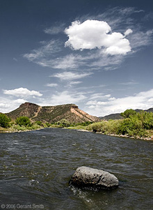
| | Stone has been documenting his journey from the headwaters of the Rio Grande at the continental divide near Creede, Colo., to the Gulf of Mexico. |
For nearly nine months, Nat Stone has been navigating a “political line” floated down the Rio Grande in a hybrid canoe/kayak he crafted from Spanish cedar.
He travels with a tent, pillow, blanket, tarp, clothing, camera and map. He’s packed food supplies and 4 gallons of water, waterproof bag and his paddles.
“One of the things I’ve been struck by is just how beautiful this river is,” Stone said from its banks near downtown Brownsville. “Between towns in places where there is very little public access, it’s really pretty. Unfortunately, the river has become such a political line.”
The Rio Grande had been a point of contention between the Mexico and the United States since Texas was annexed as a state in 1845.
Mexico decided to recognize the Rio Grande as the border with the United States in 1848 when the Treaty of Guadalupe Hidalgo that ended the war between the two countries was signed, according the Handbook of Texas Online. That was the same year Brownsville was founded.
For years, the Rio Grande sufficed as a physical barrier between the two countries, but recent immigration debates led to calls for a border fence. President Bush signed the Secure Fence Act last year, which had a provision allowing for construction of 700 miles of double-layer fencing on the border with Mexico.
Recently, local leaders found out about a map by Customs and Border Protection detailing locations for construction of the first phase of the border wall, including urban areas and sensitive natural areas. The memo addressed to “Dear Texas Homeland Security Partner” outlined a plan to build 370 miles of fence and 200 miles of vehicle barriers by the end of 2008, according to The Associated Press.
The memo and map prompted a visit to the Rio Grande Valley on May 12 by Sen. John Cornyn. Stone, who was in Mission at the time, had wanted to attend the meeting but couldn’t because all he had to get around in was his canoe.
Local leader expressed their dismay to Cornyn at the memo detailing the location of 153 miles of fencing in Texas with much of which it in the Valley.
“We left feeling we will be listened to,” Brownsville Mayor Eddie Treviño said during the meeting with Cornyn. “So, when the memos were released, needless to say, we were pretty shocked and somewhat dismayed. They told us one thing, and it appeared something else was being done.”
Stone has been documenting his journey from the headwaters of the Rio Grande at the continental divide near Creede, Colo., to the Gulf of Mexico.
His goal has been to paddle the main structure of the river basin. When he reaches the river’s end, where it empties into the gulf, he will arrive at the midpoint of his trip.
A freelance writer, Stone, 38, has long been intrigued by North America’s major waterways.
In 2002, he published a book about his adventure from the Hudson River to the Mississippi River and down to the Gulf of Mexico by way of New Orleans.
Part travelogue, part journalism, his current work takes places on rivers in the American Southwest, including the Pecos and Rio Grande.
He started in 2004, pushing off from the stony banks in Colorado, and at each turn of the river, he has been amazed at what he discovered along the way.
“The difference between that bank and this bank,” said Stone on the U.S. shore while pointing toward Mexico. “On the (Mexican) side, this is still a working river from the point of view of culture. There’s no longer a direct relationship with the river on the American side.”
From a structural standpoint, there is very little of the Rio Grande that is natural with every drop of water already assigned a predestined use, Stone said.
“It’s sort of like overbooking a flight,” he said of the water that flows in the Rio Grande. “So, there’s no bit of (of the river) that isn’t in possession.”
That major sections of the river are manufactured wasn’t a surprise, however, the contrast between people’s relationship to the river was.
“At one time, this was much more of a communal river like those cows,” he said, motioning to a small herd grazing along the grassy banks on the Mexican side.
To emphasize the contrast, Stone pointed at the dirt road under his feet and a Border Patrol vehicle on the U.S. side of the river.
Dressed in a T-shirt and stained shorts, Stone said most days, he comes across a dozen or more people on the Mexican side of the river, fishing and camping.
With the exception of designated recreation areas, such as Big Bend National Park, the U.S. side is typically absent of people.
He camps where he feels safest, and he has often enjoyed the hospitality of people he met on the way.
“If somebody is on the side of the river and they invite me to stop and talk, I could spend 10 minutes or I could spend the rest of the day in conversation,” he said.
He progresses downstream about 30 miles a day, stopping in towns along the way to gather supplies, check his email and recharge his camera.
Every so often, he has run out of money, or the river runs out of water, and he is forced to suspend his trip, but with little more than 40 miles to the Gulf of Mexico, Stone has other concerns.
“Now, I have to figure out how to get my boat back to Brownsville and then back to New Mexico,” he said. |
| |
|

