
| | |  Editorials | Environmental | December 2009 Editorials | Environmental | December 2009 
Breakthrough in Monitoring Tropical Deforestation Announced in Copenhagen
 Greg Asner - Carnegie Institution Greg Asner - Carnegie Institution
go to original
December 10, 2009
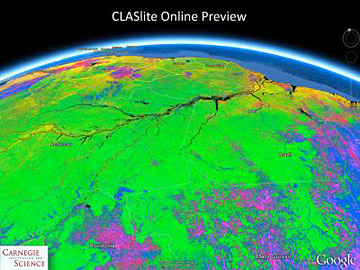
| | This CLASlite image of the Amazon Basin shows deforested regions in pink and blue and intact forests in green. (Greg Asner/CLASlite) | |
Palo Alto, CA — Tropical forest destruction accounts for some 20% of global greenhouse gas emissions. But quantifying these emissions has not been easy, particularly for tropical nations. New technology, developed by a team of scientists at Carnegie's Department of Global Ecology, is revolutionizing forest monitoring by marrying free satellite imagery and powerful analytical methods in an easy-to-use, desktop software package called CLASlite. Thus far, 70 government, non-government, and academic organizations in five countries have adopted the technology, with more on the horizon. The team announced its new web site for CLASlite users at the Copenhagen climate meetings today (claslite.ciw.edu).
To support international policy discussions and to solve on-the-ground needs for forest monitoring, CLASlite is being rapidly disseminated through a tailored, demand-driven technology transfer to government, academic and non-government institutions of the Andes and Amazon regions.
"We're providing CLASlite to support the U.N. program for Reduced Emissions from Deforestation and Degradation [REDD] and other tropical forest monitoring efforts," remarked Greg Asner, the lead scientist for the CLASlite project. "My team has already trained more than 240 users from 70 organizations in the Andes-Amazon region, and we will do more workshops in 2010."
CLASlite is a software package designed to automatically identify deforestation and forest degradation from satellite imagery. The power of CLASlite rests in its unique ability to convert seemingly green "carpets" of dense tropical forest cover in raw satellite images into highly detailed maps that can be readily searched for deforestation, logging, and other types of forest degradation. CLASlite is also a key component of a cost-effective new method developed by Carnegie that integrates satellite and airborne Light Detection and Ranging (LiDAR) mapping to support high-resolution forest carbon mapping.
"It is how we use CLASlite that will make the difference," remarked Guayana Paez-Acosta, the CLASlite coordinator for capacity building. "The new CLASlite user website is a space for collective knowledge building to improve forest monitoring and management in the Andes-Amazon region."
In addition, Carnegie has teamed up with Google.org to provide "CLASlite Online" via the web, which will greatly extend the ability of users to monitor their forests, officials from both organizations announced today.
Amy Luers, Senior Environment Program Manager for Google.org, stated that "working with Carnegie and others, we have developed a prototype imagery analysis engine to power forest-monitoring systems such as CLASlite online. By providing computational horsepower and easy access to massive data sets, this new technology will dramatically lower the cost and complexity for tropical nations to monitor their forests using CLASlite and other forest analysis programs."
In 2010, the group plans to extend the training and technology transfer to other countries in the Amazon region, and will provide the web-based version to support tropical forest mapping anywhere in the world. The CLASlite project is supported by the Gordon and Betty Moore Foundation, Google.org, and the John D. and Catherine T. MacArthur Foundation.
gasner(at)ciw.edu
The Carnegie Institution (www.CIW.edu) has been a pioneering force in basic scientific research since 1902. It is a private, nonprofit organization with six research departments throughout the U.S. Carnegie scientists are leaders in plant biology, developmental biology, astronomy, materials science, global ecology, and Earth and planetary science. The Department of Global Ecology, located in Stanford, California, was established in 2002 to help build the scientific foundations for a sustainable future. Its scientists conduct basic research on a wide range of large-scale environmental issues, including climate change, ocean acidification, biological invasions, and changes in biodiversity. |
|
| |

