
| | |  Travel & Outdoors Travel & Outdoors 
Off the Beaten Path at Mexico’s Colonial Villages
 Paula Griswold - tourism-review.com Paula Griswold - tourism-review.com
go to original
April 13, 2010
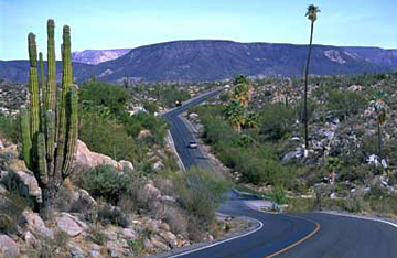
| | Mexico Trans-Peninsular Highway 1 (baja-relocation.com) | |
Several colonial villages along the Mexico Trans-peninsular Highway 1 might not be the no. 1 of the guide books but many visitors admire the charm and serenity as well as historical heritage of the region. The Mexico Trans-peninsular Highway 1 is one of the great drives of the world, and the scenery from shortly after La Paz to the Cape is dazzling: turquoise Sea of Cortez coastline, desert plains shaded by giant mesquite and flowering cholla, cordon (cacti) forests, colonial mountain villages and beach resorts, palm-filled canyons and craggy mountains.
While much of the coast is highly developed, the four inland colonial villages remain traditional and timeless, thanks in part to the formidable barrier of the Sierra de la Laguna. These villages are rich in peninsular history and perfect stopping off places on this drive.
Forty-eight km from La Paz is the first colonial village of El Triunfo, only a Jesuit cattle ranch until 1748 when silver was discovered down the road at San Antonio. It was briefly the most populous town in Baja. After the mines closed in 1926, it turned into a ghost town of whitewashed, crumbling buildings and cobblestone streets, although mining by individuals continues to this day. Visitors enjoy exploring the mine ruins, Victorian mission church and interesting piano museum.
After El Triunfo there is a steep ascent to a pull-off where on clear days the brilliant turquoise Sea of Cortez and the Isla Cerralvo can be viewed. Three km farther, a little off from the highway and at the bottom of an arroyo, is San Antonio, whose tall 19c smokestack can be seen from the road. Spanish officials met here in 1786 to plan for the building of Franciscan missions throughout Alto California, and it was briefly the capital of Baja.
Between San Antonio and the last mountain village of San Bartolo is a region of lush vegetation, flowering vines and dangerous highway curves. San Bartolo hangs off the side of a spring-filled canyon that irrigates mango, avocado, coconut and citrus groves and sugar cane. Infrequently open roadside stands sell fruit and vegetables and delectable locally-made fruit dulces. The village’s clear, perfect weather and choice of restaurants make it a haven for American and Canadian snowbirds.
On the winding descent to the sea-bordered desert plain, cordon-covered hills and rocky plateaus play hide and seek with the coast. Five km past Buena Vista resort, inside the Sierra de la Laguna biosphere reserve, is cobbled Santiago, reached by a blacktop road off the highway. It was an important colonial mission town founded in 1724. Ten years later the mission padre, two soldiers and an Indian were killed during a wide-spread Pericue Indian revolt that caused the abandonment of Jesuit missions in the Cape and La Paz. The highway passes a Tropic of Cancer cement ball marker, and the leather crafts and basil-growing town of Miraflores, before reaching the Cape. |
|
| |

