 |
|
|
 News Around the Republic of Mexico | January 2006 News Around the Republic of Mexico | January 2006 
Activists to Provide Migrants Border Maps
 Jo Tuckman - Guardian Jo Tuckman - Guardian
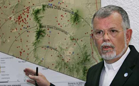
| | Danger zone: Reverend Robin Hoover, president of the Humane Borders group, points out the red dots on a map of the Arizona desert showing where illegal immigrants died while seeking a better life in the US. (AP) |
Mexico's national human rights commission has announced it will give would-be migrants detailed maps of the Arizona desert, the most popular — but riskiest — clandestine immigration corridor into the United States.
The maps are unlikely to go down well among advocates of a US bill designed to toughen control of the 3000-kilometre border, due to be debated in the Senate next month.
"What's next? Are they going to buy them bus tickets to Chicago?" said Mark Krikorian, executive director of the Centre for Immigration Studies, a Washington think tank.
"It's clearly a bad thing for Mexico to be encouraging illegal immigration."
But Mauricio Farah of the human rights commission, which is technically independent but government-funded, said that although the commission recognised the right of every country to define its migration policy, "nothing can be above basic human rights".
"Our intention is not to encourage migration but to save lives," he said.
Mr Farah told a news conference that about 500 Mexicans died trying to cross into the US last year, the highest ever death toll. Many of them perished in the desert, he said, because they were unprepared for the hardships they encountered.
The maps, put together by the Arizona-based humanitarian group Humane Borders, mark the area's topographical features, provide estimates of how many days it takes to cross and information on where migrants can find water stations en route or rescue beacons to summon the border patrol. Red dots indicate the places where migrants have died in the past.
The maps also warn migrants to travel only with trusted companions and to take appropriate clothing as well as plenty of water and food. They advise against attempting the journey in the hottest months of the year, when temperatures in the desert regularly exceed 40 degrees.
Humane Borders' president, Reverend Robin Hoover, said maps were needed in southern Mexico so migrants could weigh the risks before leaving home. Some of the posters have warnings such as "Don't go. There isn't enough water."
However, officials conceded many migrants were unlikely to heed the advice. |
| |
|

