 |
|
|
 News Around the Republic of Mexico | September 2006 News Around the Republic of Mexico | September 2006 
Emergency in Mexico's Baja California as Hurricane Nears
 AFP AFP
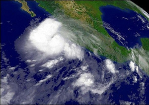
| | National Oceanic and Atmospheric Administration (NOAA) satellite image shows Hurricane John. With a stronger and meaner Hurricane John threatening to make landfall, three towns in Mexico's Baja California peninsula have been placed under a state of emergency, and 15,000 people have been evacuated to safety. (AFP/NOAA) |
With a stronger and meaner Hurricane John threatening to make landfall, three towns in Mexico's Baja California peninsula have been placed under a state of emergency, and 15,000 people have been evacuated to safety.
"The Interior Ministry's Civil Safety department has issued a state of emergency for the municipalities of Los Cabos, La Paz and Comondu, in Baja California state, because of Hurricane John," the ministry said in a statement late Thursday.
Baja California civil safety director Jose Gajon said 15,000 people in the three municipalities were being evacuated to 131 shelters that can withstand the storm's powerful winds.
The storm strengthened from a category-two to a category-three storm overnight, with maximum sustained winds now reaching 185 kilometers (115 miles) per hour, according to the Miami-based National Hurricane Center (NHC).
It was projected to reach the tourist resort of Cabo San Lucas on Friday after drenching other Pacific coastal areas.
Puerto Vallarta, another favorite tourist destination, was also dangerously close to the storm's projected path.
On Thursday, John had lost some of its power, decreasing to category two from a dangerous four on the five-level Saffir-Simpson intensity scale, when it packed sustained winds of 205 kilometers (125 miles) per hour.
More "fluctuations in intensity are likely during the next 24 hours," the NHC said.
Forecasts said it was unlikely the storm would hit another part of the Mexican coast before it slams into the Baja California peninsula, although any slight deviation from the projected track could easily take it inland.
Even if the coastline does not get the full power of the storm, it is likely to be hit by winds up to hurricane force, the NHC said.
Hurricane warnings have been issued for a stretch of about 400 kilometers (250 miles) of the mainland's coastline as well as the southernmost areas of the Baja California peninsula.
Authorities in the state of Jalisco had ordered the evacuation of 8,000 people and urged others to board up their homes as the hurricane drenched much of the region.
Earlier in the week, winds and rain propelled by the storm uprooted trees and caused mudslides in the seaside resort of Acapulco.
The forecasters warned that 15 to 25 centimeters (six to 10 inches) of rain could cause "life-threatening flash floods and mudslides," while "large and dangerous battering waves" should be expected in areas close to the hurricane's path.
The US State Department issued a warning stating that US citizens in the Cabo San Lucas/Baja California region "should immediately head to higher ground and/or identify shelter, monitor local media reports and follow the instructions of local emergency officials.
"Visitors should be familiar with their hotel or cruise ship evacuation plans. US citizens should carry their travel documents (including US passport, birth certificate and photo ID) with them at all times or secure them by placing them in a safe, waterproof location."
At 0900 GMT, the hurricane's eye was located 175 kilometers (110 miles) southeast of Baja California's southern tip and was moving toward the northwest at 20 kilometers (13 miles) per hour, the NHC said.
About 1,000 kilometers (600 miles) farther west, the weaker Hurricane Kristy was blowing over open Pacific waters and not threatening land, the NHC said. |
| |
|

