 |
|
|
 News Around the Republic of Mexico | July 2007 News Around the Republic of Mexico | July 2007 
Mexico Cruisers Urged to Prepare for Hurricanes
 Ambrosia Sarabia - The Log Newspaper Ambrosia Sarabia - The Log Newspaper
go to original
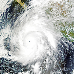
| Hurricane Kenna - Packing winds of 160 mph, Hurricane Kenna intensified into a Category 5 storm on Oct. 25, 2002. Kenna is shown in this true-color image bearing down on Mexico's West Coast, according to MODIS Land Rapid Response Team, NASA GSFC. (Jesse Allen/NASA Earth Observatory)
Hurricane History
The following major hurricanes have hit Baja California since 1968:
2006: John, Paul
2003: Marty, Ignacio
2001: Juliette
1998: Isis
1997: Nora, Flossie
1996: John, Fausto
1995: Ismael
1976: Liza
1968: Pauline |
NOAA predicts above-normal season for Atlantic storms.
Summer is an ideal time to take to the water and cruise to new or familiar destinations. However, boaters who find themselves in Mexican waters should be aware of the seasonal potential for hurricanes and tropical storms. This year, the National Oceanic and Atmosphere Administration (NOAA) Climate Prediction Center is projecting a 75-percent chance for an above-normal Atlantic hurricane season.
Boaters in Mexican waters, and those in other hurricane-prone regions, are urged to be prepared for the increase during 2007 hurricane season, which began June 1. An above-average season is expected this year for hurricanes originating in the Atlantic Ocean. Boaters are urged to take precaution while cruising south, as Atlantic-originating hurricanes can cross into the Pacific.
"For the 2007 Atlantic hurricane season, NOAA scientists predict 13 to 17 named storms, with seven to 10 becoming hurricanes - of which three to five could become major hurricanes of Category 3 strength or higher," said retired Navy Vice Adm. Conrad C. Lautenbacher, undersecretary of commerce for oceans and atmosphere and NOAA administrator.
An average Atlantic hurricane season brings 11 named storms - with six becoming hurricanes, including two major hurricanes.
On May 22, NOAA scientists released their 2007 forecast for hurricanes generating in the Eastern Pacific region, predicting a below-normal level of activity in the Eastern Pacific - with 12 to 16 named storms, of which 6 to 9 were expected to become hurricanes, and 2 to 4 expected to become major hurricanes.
Boaters should take both of these reports into consideration if they cruise South of the Border.
Veteran Mexico cruiser Pat Rains, The Log's Under Way columnist, advised boaters to monitor the weather, choose a hurricane hole and prepare vessels for the season.
"Pick one or two hurricane holes, and make them your summer headquarters - but pick ones that have plenty of nearby getaway anchorages and shore-based activities, so you won't get cabin fever," Capt. Rains advised. "Make sure you have a safe weather window to move from one hurricane hole to the next."
A few hurricane holes where boaters can house their vessels include Marina Isla Navidad at Barra Navidad; marina basins near Puerto Vallarta, Pichilingue and Marina CostaBaja at La Paz; Puerto Escondido; Marina San Carlos at San Carlos, Sonora; Puerto Don Juan near Bahia de Los Angeles in the upper Sea of Cortez; Puerto Pe'asco in the upper Sea of Cortez.
Travelers should monitor weather broadcasts and chart each tropical depression that forms, to stay aware of named tropical storms and hurricanes that may develop. Most importantly, charting these weather changes will help boaters realize when storms are moving in their direction.
Climate patterns responsible for the expected above-normal hurricane activity continue to be the ongoing warmer-than-normal sea surface temperatures in the Atlantic Ocean and the El Ni'o/La Niña cycle.
"There is some uncertainty this year as to whether or not La Niña will form; and, if it does, how strong it will be," said Gerry Bell, lead seasonal hurricane forecaster at the NOAA Climate Prediction Center.
"The Climate Prediction Center is indicating that La Niña could form in the next one to three months," Bell added. "If La Niña develops, storm activity will likely be in the upper end of the predicted range, or perhaps even higher, depending on how strong La Niña becomes. Even if La Niña does not develop, the conditions associated with the ongoing active hurricane era still favor an above-normal season."
If the talk of hurricanes and tropical storms is enough to make you leave Mexico this summer, especially during the peak season from August through October, there are some guidelines to follow to ensure your vessel stays safe if you leave it South of the Border. during the rough weather.
"If you leave your boat in Mexico over the summer, berth it in a well-sheltered marina -and pay someone (a professional skipper or marina staffer) to be responsible for its safety, to check the dock lines, fenders, chafe gear, bilges and rigging. If you simply ask friends to 'keep an eye on it,' as a storm approaches, they might understandably be way too busy taking care of their own boats," Rains said.
If boats are left in a marina, boat owners are encouraged to take the time to remove items from decks that provide wind resistance, such as sails, dinghies, poles, jugs, deck cushions, deck chairs, coolers, side curtains, awnings and tarps. "When almost 100 boats in Marina de La Paz were destroyed by Hurricane Marty in 2003, the first things that were shredded were all the head sails still furled on the forestays or booms," Rains said. "The first things to get airborne were dinghies left on deck."
Another important move is to securely tie your vessel, so strong winds and currents do not sweep it away.
Rains advises buying extra line and make it up into heavy-duty dock lines - and double up the dock lines. Next, set up your dock lines so your boat is centered in the middle of your slip, equal distance from other boats or dock fingers. Then add chafe gear to these lines, and tie the chafe gear in place, so it can't work down or up the dock lines.
Boat owners who store their vessels in dry stack facilities should also be cautious of the storage facility to confirm little to no harm will come their boats way during a hurricane.
"If you leave your boat in a dry storage yard, pick a yard that offers large concrete slabs for flooring, not asphalt or dirt," Rains said. "In the tropical heat of summer, the thin layer of asphalt can become soft, and during torrential downpours of summer hurricanes, the ground beneath the jack-stands can get water-logged."
Both conditions can cause the jack stands to sink, which can result in your boat tipping into a neighboring vessel or onto the ground.
For more information on preparing for a hurricane, visit BoatUS.com |
| |
|

