
| | |  News Around the Republic of Mexico | October 2009 News Around the Republic of Mexico | October 2009 
Tropical Storm Hits Mexican Resort, Topples Trees
 Guillermo Arias - Associated Press Guillermo Arias - Associated Press
go to original
October 21, 2009
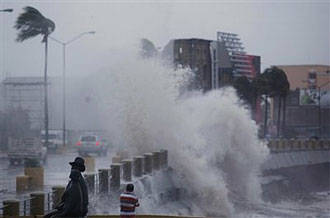
| | Waves crash against the sea wall as Tropical Storm Rick hits Mazatlan, Mexico, Wednesday, Oct. 21, 2009. Tropical Storm Rick weakened rapidly as it headed for Mexico's Pacific coast after sparing Baja California's resorts a direct blow. (AP/Guillermo Arias) | |
Mazatlan, Mexico — Tropical Storm Rick hit Mexico's Pacific coast just north of the resort of Mazatlan on Wednesday, toppling trees and signs, after sparing Los Cabos on the Baja California peninsula a direct blow.
The center of the storm made landfall around 10 a.m. EDT (1400 GMT) with winds of about 55 mph (90 kph), kicking up high waves that drew residents of Mazatlan to the city's seaside boulevard to watch the spectacle.
After moving over land, the storm quickly degenerated into a tropical depression, with winds of about 35 mph (55 kph), and was expected to soon dissipate, the U.S. National Hurricane Center said.
Authorities had no immediate reports of significant damage, though a steady rain had pelted the city since late Tuesday and several trees were toppled by the storm's winds. Electrical power was knocked out in parts of the city, Sinaloa Gov. Jesus Aguilar told local media.
Authorities canceled classes in the southern part of Sinaloa state, where Mazatlan is located, and urged residents to evacuate some low-lying neighborhoods.
Tourists in Los Cabos, meanwhile, awoke to a blue, cloud-streaked sky Wednesday morning. There were no reports of flooding overnight, according to Los Cabos civil defense director Francisco Cota.
Forecasters said Rick could dump as much as 6 inches (15 centimeters) on isolated parts of Sinaloa and Durango states, creating the risk of flash floods and mudslides.
Over the weekend, Rick's winds were clocked at 180 mph (290 kph) – making it the strongest hurricane in the eastern North Pacific region since 1997 – and it kicked up high waves hundreds of miles (kilometers) away that killed at least two people. But the storm spent its force far out at sea and weakened over cooler waters.
Meanwhile, far out in the Pacific Ocean, Hurricane Neki was centered about 640 miles (1,024 kilometers) west-southwest of Honolulu and about 195 miles (312 kilometers) east of Johnston Island. Maximum winds were at about 105 mph (170 kph).
A hurricane watch was issued for the Papahanaumokuakea National Monument, a marine conservation area northwest of Hawaii.
Forecasters predicted Neki would probably pass wide of tiny Johnston Island.
The uninhabited island, which is part of the isolated Johnston Atoll, is under the primary jurisdiction and control of the U.S. Air Force. The U.S. Fish and Wildlife Service has a national wildlife refuge there.
Also Wednesday, a river overflowed its banks in the Central American nation of Honduras, flooding hamlets and cutting off transport routes to several towns on the country's Caribbean coast.
Juan Cesar Cruz, the head of Honduras' civil defense agency, said a dozen roads had been cut by the flooding. The flooding was caused by heavy rains that started Sunday.
|
|
| |

