
| | |  News Around the Republic of Mexico News Around the Republic of Mexico 
Tropical Storm Karl Makes Landfall in Yucatan
 BBC News BBC News
go to original
September 16, 2010
UPDATE: Tropical Storm Karl picked up power as it moved across the southwestern Gulf of Mexico and was expected to become a hurricane later on Thursday as it headed for the coast of eastern Mexico.
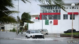
| | Cars are driven through a flooded street in Chetumal, Yucatan Rainfall from Tropical Storm Karl brought new flooding to Mexico. | |
Mexico's Yucatan Peninsula has been hit by heavy rain and high winds after Tropical Storm Karl made landfall.
The storm downed trees and power lines, leaving about 10,000 homes without electricity after making landfall near Puerto Bravo, in Quintana Roo state.
It is forecast to move over the Gulf, gaining strength as it goes.
Out in the Atlantic a rare duo of hurricanes are churning, the first time in a decade that two simultaneous Category Four storms have been seen.
By 0600 GMT the eye of Tropical Storm Karl was located 75km (50 miles) to the south-west of Campeche, according to the Miami-based National Hurricane Center (NHC), and the wind speed had declined to about 40mph (65km/h).
The centre warned that up to 20cm (20in) of rain could fall, causing "life-threatening flash floods and mud slides" particularly in mountainous areas, and that there could be coastal flooding.
Life-threatening swells
Forecasters are predicting that Karl will move across the Gulf of Mexico, picking up speed as it goes, becoming a hurricane by the weekend.
It is threatening to "pass very nearby" Pemex oil company installations, Jaime Albarran of the National Weather Service told AFP.
"Karl will move across the southern Gulf of Mexico and approach the coast of the state of Veracruz within the hurricane watch area by Friday," the NHC said.
Tropical Storm Karl, Hurricane Igor and Hurricane Julia seen from space From space the two Atlantic hurricanes and the tropical storm making landfall are clearly visible
Twenty-five people have been killed and almost a million people been affected by floods already this month in Mexico, which is in the grips of its annual rainy season.
Out in the Atlantic, Hurricane Julia has weakened slightly from a Category Four to a Category Three hurricane, with winds of up to 185km/h.
Hurricane Igor, the other hurricane out in the Atlantic, remains a large-scale Category Four Storm with top wind speeds of 215km/h - making it the most powerful hurricane of this season.
The NHC describes Igor as "extremely dangerous" and while the hurricane is not expected to make landfall for days, forecasters say that Puerto Rico, the Virgin Islands and Bahamas are likely to feel the effects of storm swells by early on Thursday, and the US East Coast by the weekend.
"These swells are likely to cause life-threatening surf and rip current conditions," the NHC warned.
|
|
| |

