

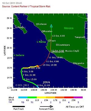
Puerto Vallarta, Mexico - Early this morning, Mexico's Sistema Nacional de Protección Civil (SINAPROC) issued a Yellow Alert for the states of Colima and Jalisco, in response to the strengthening of Jova, now a Category 3 hurricane on the Saffir-Simpson scale.
Data supplied by the US Navy and Air Force Joint Typhoon Warning Center suggest that the point of landfall will be near 19.0 N, 104.5 W. Jova is expected to bring 1-minute maximum sustained winds to the region of around 185 km/h (114 mph). Wind gusts in the area may be considerably higher.
According to the Saffir-Simpson damage scale the potential property damage and flooding from a storm of Jova's strength (Category 3) at landfall includes:
• Storm surge generally 2.7-3.7 metres (9-12 feet) above normal.
• Some structural damage to small residences and utility buildings with a minor amount of curtainwall failures.
• Damage to shrubbery and trees with foliage blown off trees and large trees blown down.
• Mobile homes and poorly constructed signs are destroyed.
• Low-lying escape routes are cut by rising water 3-5 hours before arrival of the centre of the storm.
• Flooding near the coast destroys smaller structures with larger structures damaged by battering from floating debris.
• Terrain continuously lower than 1.5 metres (5 feet) above mean sea level may be flooded inland 13 km (8 miles) or more.
• Evacuation of low-lying residences within several blocks of the shoreline may be required.
There is also the potential for flooding further inland due to heavy rain.
BN Editor's Note: Though the most probable outcome is that Jova will be hitting the mountains behind Banderas Bay, given the Yellow Alert issued by SINAPROC for the state of Jalisco, residents and visitors should stay on alert as heavy rains and 10 foot swells are predicted in the area.