

UPDATE: At 2 pm PDT on May 24, 2012, the government of Mexico issued a tropical storm watch in effect for the coast of Mexico north of Cabo Corrientes to San Blas. Tropical storm conditions are possible within the watch area by Friday night.
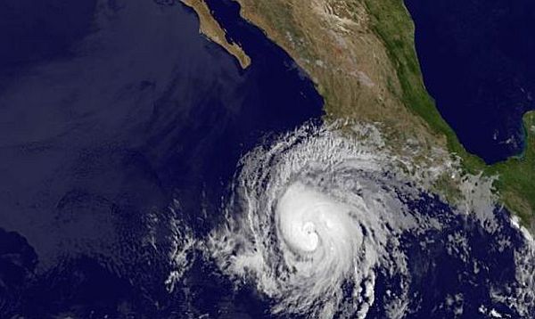
Mexican Pacific Coast - Hurricane Bud developed into a Category 2 storm as it churned northeast in the Pacific, threatening the Mexican coast with high wind and surf and heavy rain through the weekend.
The storm's top winds reached 105 miles (169 kilometers) per hour, up from 85 mph earlier today, according to an advisory from the U.S. National Hurricane Center just before 11 a.m. New York time (EDT). Bud is expected to strengthen further before weakening and turning back out to sea.
"Swells generated from Bud will begin affecting portions of the southern and southwestern coasts of Mexico later today," the advisory said. "These swells are likely to cause life- threatening surf and rip current conditions."
The system was 280 miles southwest of Manzanillo and moving north-northeast at 8 mph.
Ahead of Bud's expected path, the government of Mexico issued a tropical-storm warning and a hurricane watch for the coast from Punta San Telmo to Cabo Corrientes. The warning means winds of at least 39 mph are possible within 36 hours and the watch means hurricane conditions may arrive in two days.
Hurricane-force winds of at least 74 mph extended as far as 25 miles from Bud's center. Rainfall of as much as 10 inches (25 centimeters) in the states of Michoacan, Colima, Jalisco and southern Nayarit may cause dangerous flooding, the NHC said.
A U.S. reconnaissance plane will fly into the hurricane later today.
High Winds
Tropical storm-force winds are expected along the southwest coast tomorrow with hurricane-force winds possible in the watch area by tomorrow night.
The NHC said the storm is expected to grow in strength today, then encounter cooler waters and increasing shear that should cause weakening. Bud will probably turn back from near the coast this weekend and become a depression May 28 as it moves west into the Pacific.
The NHC is also monitoring a low-pressure area stretching across Cuba to the Florida Straits that has a 20 percent chance of developing in the next 48 hours. It may organize into a tropical or subtropical system over the weekend as it moves northeast, the center said. Heavy rain may fall in parts of southern Florida, the Bahamas, Cuba and the Cayman Islands.