

El Tuito, Jalisco, Mexico - Cabo Corrientes is one of those vaguely heard of places where nobody ever goes because... well, where is it? And how would you go there? And why?
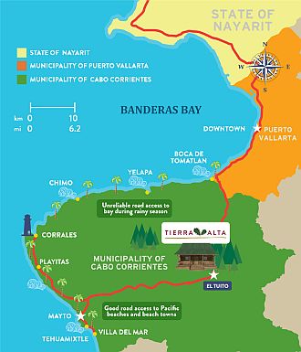
Literally, Cabo Corrientes means "Cape Currents." It's the defining end point of Banderas Bay west of Puerto Vallarta where the bay finally gives up its apparent attempt to swallow the Pacific. Look at the map - you'll see that as the bay opens and yawns to the southwest, its lower prognathous jaw begins to fall away at the tiny coastal town of El Chimo.
At the very end of this lower jaw is the town of Corrales where the old lighthouse is located at the Cape. Also called Cabo Corrientes is the municipality that includes about 75 kilometers of beautiful and rarely visited beaches, beginning with the entire lower jaw of Banderas Bay and ending along the Pacific Coast as far south as the town of Villa del Mar.
From Vallarta itself, you can't quite ever see the last bay-defining point marked by the old Cape lighthouse at Corrales. You can occasionally see that far end of the bay on a clear day from the opposing upper jaw at Punta Mita, whose residents are generally too happily distracted by golf to be much interested in aquatic geography.
 |
Past Chimo, you are at a kind of geographic and psychological tipping point. Ocean swells now rise and fall with their own remorseless rhythm, indifferent to your condition. At that point, you have lost the bay's protection. And if you then round the cape and head south along the Cabo Corrientes shoreline, you can feel the profound difference between a defined bay and the open, endless Pacific domain.
Of course, all bays are defined by their partial closure against wind and water. The Bay of Banderas is just such a protective zone. Its orientation denies direct admission to most hurricanes. But it is large and deep enough (maybe 3,000 feet) to offer a complete oceanic environment with enough aquatic scale for humpback whales, giant manta rays, tuna, dolphins and marlin.
There are times that Banderas Bay seems like a relatively safe theme park for seafarers who don't really want to go to sea. In fact, Banderas Bay seems to have been artfully designed for vacations and retirement. It appears to have been invented for people who believe they have suffered enough, so bring on the paradise, now, please.
But if you drive 25 minutes west from Vallarta along coastal Highway 200, you will cross into the Cabo Corrientes municipality just past Boca de Tomatlan. You are, in a sense, rounding the cape by land. The road abruptly leaves the coast, swings due south and inland toward the town of El Tuito in the foothills of the Sierra Cuale Mountains.
The winding road climbs into the pine and oak forests and you will begin to notice that, by contrast to the dense human landscape of Vallarta, there is just a thin scattering of people in the small clustered settlements along the road. You are in Cabo Corrientes.
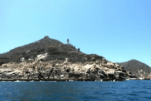
A look at the Cabo Corrientes lighthouse at Corrales
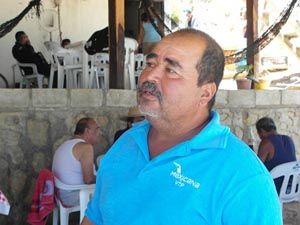 |
| Cabo Corrientes lighthouse keeper Hector Hernandez |
The place where no one's there
Given the remarkable technological advance at the lighthouse, it's a little strange that the nearest gas station for Corrales, the tiny lighthouse town at the cape, is back in El Tuito. And in fact, there was still no functioning gas station even in El Tuito until earlier this year - after nearly 500 years as a trading town.
Today El Tuito is an attractive municipal center of some 4,000 people. The exterior walls of the old shops around the plaza are all colored with an ochre mix of local clays. The new gas station is finally open, partly to fuel the vehicles that now make their way on passable gravel roads from El Tuito to the beautiful Pacific shores that very few people have seen.
 |
After about 45 or 50 minutes on the road from El Tuito to the coast, and you're there.
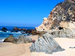
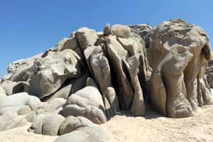
When you first reach many of these beaches, something seems missing. Then you note that there is not a single palm tree in view. Instead, there is a Sahara of rolling sand dunes and a scattering of small, roughhewn houses just inland from the beaches. One of their measures of age is the ancient, brilliant tree-sized bougainvilleas still co-existing with the human residents after generations. These rugged old plants sprawl over roofs, shouting out their defiant colors in the sun.
Cabo Corrientes is not a land of ease. How people survive here, well, it's a question that seems to have something to do with how few of them there are.
To get to Cabo Corrientes
The town of El Tuito serves as the jumping off point, the hub in the wheel for reaching all of the untamed Pacific beaches of Cabo Corrientes.
 |
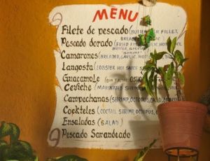
Of course, there are none of the efficient Vallarta-style Margaritaville beach installations that may recall your misspent youth in the hotel zone on Banderas Bay. But there are friendly outposts along Cabo Corrientes - rustic old handmade restaurants on the water serving cold beer and superb seafood. Fresh oysters, lobster, red snapper with garlic - all caught that morning or during the night. And now there are a few modest hotels scattered among these miniscule beach towns. Mayto has two small but comfortable hotels.
Cande's, a famous restaurant in Tehuamixtle, rents rooms and there are several other modest "Tehua" rentals available with views of the bay.
 |
But when you walk on one of these incredible broad Pacific beaches, alone, you will question whether all of humanity might have just recently moved on to some even more impossibly beautiful and remote location. At times, there just seems to be almost no one there. There will be the occasional lone fisherman sorting through his nets at the edge of the surf. A man placidly riding a horse with no apparent destination. Two men doing something to an engine in a rusted truck on a dirt road that meets the intensely blue sea.
In the somnolent hamlet of Naranjitos (population 94), a woman saw us stopped along a dirt road near the water. She then also stopped her car, restless kids in the back seat, because she assumed, smiling warmly as she called out to us, that we were lost. She wanted to offer us directions to somewhere. In her view, being lost was the only possible reason for our being in her town. If we were there, we must be lost.
Measuring absence: Population densities
The "Municipio de Cabo Corrientes" seems much too large to be a municipality (which in Mexico are entities that function like counties with a measure of independent governance). Puerto Vallarta is also a Jalisco "municipio," but it has less than half the area (680sq kms) of its municipal neighbor, Cabo Corrientes, to the southwest.
 |
| The secluded beach at Playa Amor, Mayto |
This contrast in contiguous populations is roughly equivalent to placing Massachusetts (density 331) alongside of New Mexico (density 6.6) as if they were right next door to each other, as is the case for Vallarta and Cabo Corrientes municipalities. The density contrast between Vallarta and Cabo Corrientes is extreme anywhere in the world, especially for neighboring entities that share a border.
As you enter the Cabo Corrientes municipality headed south on Highway 200, you are almost immediately in a population density of single digits, much closer to Mongolia's which may have the lowest density of any country on earth. Mongolia has only 2 people per square kilometer compared to 6.5 in Cabo Corrientes. The US, with all of those wide open spaces of the West has a density of 31 and Mexico is at 57.
Population Density Per Square Kilometer
Mongolia: 2.0
Massachusetts: 331.0
New Mexico: 6.6
Cabo Corrientes Municipality: 6.5
Puerto Vallarta Municipality: 375.0
United States: 31.0
Mexico: 57.0
For some people, low density may weaken their aesthetic response to places with scant signs of human presence. I may be attracted to these empty spaces in the world. But there are obviously millions and perhaps billions of people whose preference is for a dense coating of humanity - a kind of Coney Island of human concentration.
 |
The Mexican Tourism Board on Cabo Corrientes
Along the coast of Cabo Corrientes, around 75 kilometers in length, you'll find a set of paradisiacal beaches of fine, white sand, abundant vegetation and spectacular cliffs. Some of these beaches have barely been explored, making them ideal for those seeking to go deeper into the wilds of the Mexican coast and forget the noise and pollution of the cities. A great variety of fruits are grown in the fertile soil of Cabo Corrientes: mangoes, papayas, banana and coconuts are the main crop, and a number of enticing local dishes are prepared using them. David Kimball is a retired journalist and businessman. For 12 years he researched and wrote Special Supplements on Mexico for Business Week Magazine in Mexico City. About ten years ago, he began assembling the land parcels now called Tierra Alta, an eco-development for cabins located in an oak forest just outside of El Tuito. His wife, Xochitl, now leads the development while Kimball gradually shifts his attention to the hammock on his cabin deck. He can be reached by leaving a message with Tropicasa Realty, (322-222-6505), or by email at kimballdavid(at)hotmail.com.
 Set on 5 hectares of rolling hillsides, the Tierra Alta eco cabin development will comprise 21 country cabins built for weekend enjoyment or full-time living. With cabin/lot combined pricing starting at only $95,000 USD, reservations are already being taken. If you would like to see what the Tierra Alta lifestyle offers you, please call Tropicasa Realty's Wayne Franklin at (322) 222-6505, to set an appointment to preview the model cabin and breathe the fresh mountain air of El Tuito.
To learn more about Tierra Alta Click HERE, or visit TierraAltaTuito.com.