

Puerto Vallarta, Mexico - Hurricane Vance is maintaining its strength while continuing to churn over the waters of the Eastern Pacific, about 450 miles from Mexico's coastline.
Vance developed into a tropical storm on Friday afternoon and as it drifted in a generally westward direction, intensified to a hurricane on Sunday morning. The hurricane's maximum sustained winds Monday afternoon were near 110 mph, up from 105 mph earlier in the day. This makes Vance a strong Category 2 hurricane which could peak as a Category 3.
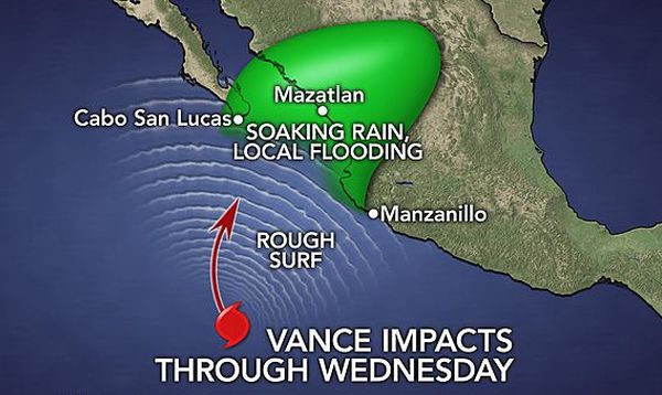
So far Vance has remained over the open waters, however, impacts to Mexico are expected as the hurricane is predicted to turn northeast back toward western Mexico through midweek.
The Mexican states of southern Baja California Sur, Sinaloa, Nayarit, and Jalisco are being put on alert for impacts from Vance as early as Tuesday. Residents of Los Cabos, Mazatlan, Puerto Vallarta, and all municipalities nearby should monitor the progress of this system closely as these locations lie within the zone of greatest risk from Vance.
The latest track of Vance brings it onshore early Thursday morning as a tropical rainstorm. Increasing wind shear is expected to cause rapid weakening as the storms nears land. Yet while Vance will be weakening, it could still bring a danger of high winds, flooding rain (4-8 inches,) mudslides, pounding surf, and rip currents.
The impacts from Vance may not stop when it moves into Mexico. Vance's heavy rain may get drawn across northern Mexico and into Texas during the middle of the week as a cold front pushes through the region.
Vance is the 20th named storm of the Eastern Pacific hurricane season. The last time 20 or more named storms formed in that basin was 1992, when the entire list of 24 names was used, ending with Tropical Storm Zeke.
Zeke is also the "Z" storm on this year's list. Eastern Pacific names rotate every six years unless retired, except for names starting with X, Y, and Z. Those are rarely used, and thus just two names are on the list for each of those letters, one male and one female, alternating every other year.