

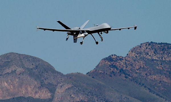
The US now patrols nearly half of the Mexican border using drones alone, in a largely unheralded shift used to control desolate stretches where there are no agents, camera towers, ground sensors, or fences. Plans are to expand the strategy to the Canadian border as well.
It represents a significant departure from a decades-old approach that emphasizes boots on the ground and fences. Since 2000, the number of Border Patrol agents on the 1,954-mile border more than doubled to surpass 18,000 and fencing multiplied nine times to 700 miles.
Under the new approach, Predator Bs sweep remote mountains, canyons, and rivers with a high-resolution video camera and return within three days for another video in the same spot, two officials with direct knowledge of the effort said on condition of anonymity because details have not been made public.
The two videos are then overlaid for analysts who use sophisticated software to identify tiny changes — perhaps the tracks of a farmer or cows, perhaps those of immigrants who entered the country illegally or a drug-laden Hummer, they said.
About 92 percent of drone missions have shown no change in terrain, but the others raised enough questions to dispatch agents to determine if someone got away, sometimes by helicopter because the area is so remote. The agents look for any sign of human activity — footprints, broken twigs, trash.
About 4 percent of missions have been false alarms, like tracks of livestock or farmers, and about 2 percent are inconclusive. The remaining 2 percent offer evidence of illegal crossings from Mexico, which typically results in ground sensors being planted for closer monitoring in those locations.
The government has operated about 10,000 drone flights under the strategy, known internally as "change detection," since it began in March 2013. The flights currently cover about 900 miles, much of it in Texas, and are expected to expand to the Canadian border by the end of 2015.
The purpose is to assign agents where illegal activity is highest, said R Gil Kerlikowske, commissioner of Customs and Border Protection, the Border Patrol's parent agency, which operates nine unmanned aircraft across the country.
 |
| Border Patrol Chief Michael Fisher |
"You have finite resources," he said in an interview. "If you can look at some very rugged terrain and you can see there's not traffic, whether it's tire tracks or clothing being abandoned or anything else, you want to deploy your resources to where you have a greater risk, a greater threat."
If the video shows the terrain unchanged, Border Patrol Chief Michael Fisher calls it "proving the negative" — showing there isn't anything illegal happening there and therefore no need for agents and fences.
The strategy was launched without fanfare and expanded at a time when President Barack Obama prepares to issue an executive order by the end of this year to reduce deportations and enhance border security.
Representative Michael McCaul, a Texas Republican who chairs the House Homeland Security Committee, applauded the approach while saying that surveillance gaps still remain. "We can no longer focus only on static defenses such as fences and fixed camera towers," he said.
Senator Bob Corker, a Tennessee Republican who co-authored legislation last year to add 20,000 Border Patrol agents and 350 miles of fencing to the southwest border, said, "If there are better ways of ensuring the border is secure, I am certainly open to considering those options."
Border missions fly out of Sierra Vista, home of the US Army Intelligence Center at Fort Huachuca, or Corpus Christi, Texas. They patrol at altitudes between 19,000 at 28,000 feet and between 25 and 60 miles of the border.
The first step is for Border Patrol sector chiefs to identify areas that are least likely to attract smugglers, typically far from towns and roads. Analysts scour the drone videos at operations centers in Grand Forks, North Dakota; Riverside, California; and Sierra Vista. After an initial survey, the drones return within a week for another sweep.
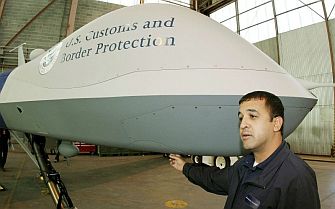
Privacy advocates have raised concerns about drones since Customs and Border Protection introduced them in 2006, saying there is potential to monitor innocent people under no suspicion. Lothar Eckardt, the agency's executive director of national air security operations, said law-abiding people shouldn't worry and that cameras are unable to capture details like license plate numbers and faces on the ground.
Eckardt looked on one September morning as a drone taxied down a runway in Sierra Vista, lifted off with a muffled buzz, and disappeared over a rocky mountain range into a blue Arizona sky. About a dozen computer screens line the wall of their trailer, showing the weather, maps and real-time images of the ground below.
Eckardt said there is "no silver bullet" to border security but that using drones in highly remote areas is part of the overall effort. If there's nothing there, he said, "Let's not waste the manpower here. Let's focus our efforts someplace else, where they're needed."
Original AP Story