

Puerto Vallarta, Mexico - Last week, the Mascota-Las Palmas highway leading to Puerto Vallarta was closed due to landslides along a 9-kilometer stretch. The road will remain closed until September 5, due to continuing landslides triggered by the ongoing rains in the Banderas Bay area.
According to a report by AccuWeather meteorologist Eric Leister, there's more stormy weather to come for Puerto Vallarta, the Riviera Nayarit and along the coast of western Mexico this week:
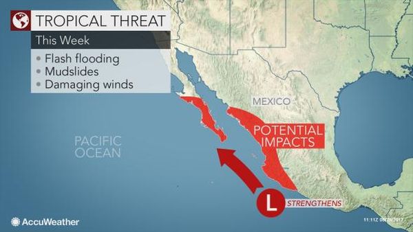
New Tropical Threat to Unleash Flooding Rain on Western Mexico This Week
A large area of showers and thunderstorms associated with an area of low pressure off the coast of western Mexico will heighten the risk for flooding and mudslides this week.
This area of low pressure is expected to become better organized as it tracks northwest parallel to the Mexico coastline and may become a tropical storm as early as Wednesday.
The potential tropical storm will remain offshore through Wednesday but could approach the southern tip of Baja California Sur on Thursday and Friday.
Despite remaining offshore, flooding downpours will stream into the Mexico coastline throughout the states of Michoacan, Colima and Jalisco through Wednesday.
"Rainfall amounts of 50-100 mm (5-10 inches) will be common near the coast with locally higher amounts in the mountains," said AccuWeather Senior Meteorologist Rob Miller.
Flash flooding will be the most widespread threat; however, there will also be a high risk for mudslides. This combination will lead to numerous travel delays across the region.
Downpours will expand into Nayarit Wednesday afternoon and southern Sinaloa Wednesday night then reach central Sinaloa and Baja California Sur on Thursday.
At this point, the strengthening tropical system could be a strong tropical storm or perhaps a hurricane as it brings threats ranging from flash flooding to mudslides and damaging winds to Baja California Sur.
Rounds of downpours and strong winds will lash areas from Nayarit and Sinaloa through Baja California Sur from Friday through Sunday.
Weakening is expected as the storm tracks farther north. Impacts to northern Baja California will be limited to enhanced showers and thunderstorms this weekend.
No widespread flooding is expected in northern Baja California, and the storm will turn west and dissipate without causing any direct impacts to the United States.
Go to original