

Mexico City - The National Autonomous University of Mexico (UNAM) is currently working on the development of an early warning system for natural disasters that will give both the government and the population more time to prepare for threats such as tropical storms, hurricanes, fires, lightning strikes, and ash plumes.
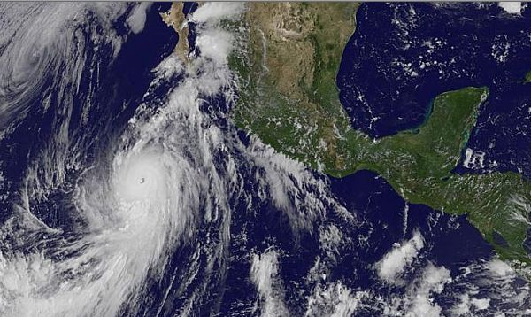
Timely diagnoses, which are needed to generate these tools, are issued from the National Laboratory for Observation of the Earth (LANOT), a state-of-the-art installation that uses three satellites to generate an image of the Earth's Surface every 15 minutes.
"We have to reduce risks so people aren't exposed to natural disasters," said Jorge Prado Molina, a LANOT coordinator and academic technician at UNAM's Institute of Geography.
 |
Whenever hurricanes, cold fronts, and other hydro-meteorological phenomena occur, they attract clouds, which can ultimately generate severe storms. If scientists are able to predict these progressions, timely flood alerts may be issued, among other things, to prevent natural disasters.
Through satellite imagery "we can monitor a hurricane's progression firsthand. We can also identify wind speed, cloud height, and temperature," claimed Prado Molina.
On the other hand, the occurrence of lightning strikes are a significant cause of death in the national territory, since they encompass severe electrical shocks that are often related to extreme hydro-meteorological events.
"Lightning strikes are often signs of an incoming tornado and they may act as indicators," commented the academic, adding that the data obtained from the satellite imagery should be adapted to the country's needs; each lightning bolt should be located and geo-referenced. "We need to know their exact coordinates so that we may assess the lightning's spatial distribution."
Prado and his colleagues from LANOT work in close cooperation with the Federal Electricity Commission (CFE) to monitor lightning and emitted electrical discharges.
The fire warning system is prepared at LANOT in cooperation with the National Commission for the Knowledge and Use of Biodiversity (CONABIO). Investigators from the Technology and Applied Science Institute (ICAT), and the Institute of Geography are collaborating in the research project.
As for ash plumes coming from central Mexico's volcanoes, the National Center for Prevention of Disasters (CENAPRED) is participating alongside experts from the Institute of Geography, ICAT, and the Geophysics Institute.
A fifth warning alert for solar storms is currently at a planning stage within the National Laboratory of Space Weather (LANCE) in the Institute of Geography. "The Sun can tell us many things about what happens here. It directly affects the Earth's magnetic field, which shields our world from radiation coming from outer space," he explained.
Original article